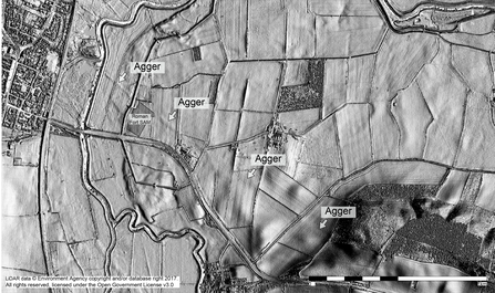
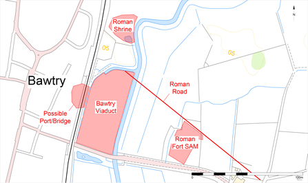
The floodplain of the Idle at this location was once part of a Roman landscape, located on one of the major roads built by the Roman military. The marshy ground was unsuitable for settlement but the land here holds evidence of a nationally important landscape containing the remains of Roman structures. Archaeological investigations and surveys using aerial photography and lidar (light detection and ranging) have enabled archaeologists to piece together this evidence to better understand this part of the Washlands.

To the east, the remains of the Scaftworth Roman fort and a section of Roman road have been designated by Historic England as a Scheduled Monument (no. 1018529). Pottery found during archaeological investigations has dated the fort to the second half of the 4th century AD. Aerial photographs show that the fort had a bank and a triple ditch around it enclosing an area of 0.4ha. The photos also show signs of a possible earlier fort beneath. The 4th century fort is aligned to a road which predates it. As a small fort, it would have held less than 100 soldiers and would have guarded the access route across the River Idle.
The road, known as Roman Road 28a, is an offshoot of a major road called Ermine Street which ran from Londinium (London) to Eboracum (York). It splits from Ermine Street to the north of Lincoln and crosses the River Trent at the Roman town of Segelocum (Littleborough). Lidar images show the road running from the south-east to the north-west across the floodplain near the fort towards the Idle. It presumably crosses the Idle and then continues on to Danum (Doncaster). Archaeological excavation in 1995 as part of the Humber Wetlands Project showed that the road had two phases. The first phase was constructed from earth and timber. The second phase used oak pegs and a gravel agger (‘mound’). It was 7m wide and its construction would have given the road stability on the marshy ground. Timbers from the second phase were radiocarbon dated to the 3rd century AD.

A possible Roman shrine was discovered to the north on a ridge of gravel within the floodplain. Column bases of a building were revealed during investigations. Pottery dating from the 3rd and 4th centuries AD suggested a religious use and indicates that this is another late Roman structure along the road.

Contains public sector information licensed under the Open Government Licence v3.0. Text and images supplied by Trent & Peak Archaeology.
